The Department for Energy Security & Net Zero (DESNZ)'s UK Geothermal Platform (UKGTP) is a freely available geothermal energy information hub. Summary layers provide a map overview of geothermal energy potential for four technologies, whilst a map explorer and a data access page enable you to view more detailed geoscientific datasets from several organisations. A user guide and examples are also provided.
Renewable geothermal and related underground thermal-energy storage technologies have the potential to decarbonise heating, cooling and energy storage across the UK as it moves towards net zero emissions. The potential varies, depending on the subsurface geology and type of technology. Some areas of the UK currently have potential for geothermal power and heat, and innovations being demonstrated globally are likely to broaden those areas.

Quick links
Who is it for?
This platform is for those interested in using geothermal energy who need summary information for an overview of the geothermal potential of an area; a local authority considering geothermal energy in heat network planning, for example. The summary information is not for detailed planning of projects. Specialists can use the platform to access geothermal and geoscientific datasets to include in site-specific pre-feasibility studies.

Policy makers
Shaping geothermal policy

Local and regional Government
Driving geothermal adoption

Regulators and government bodies
Overseeing subsurface heat

Geothermal developers
Building geothermal solutions

Academics and other researchers
Advancing geothermal knowledge
Map explorer
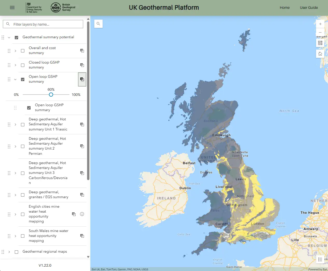
The map explorer is a user-friendly interface for visualising and examining spatial summary and data layers. There are summary layers for:
- shallow, vertical closed loops with ground-source heat pump
- shallow, open loops with ground-source heat pump
- deep, hot, sedimentary aquifers (hydrothermal)
- deep, engineered geothermal systems in granites (petrothermal)
The summary layers include indications of thermal output, temperature and cost information from the Arup 2025 study.
Access the Map explorer How to use the UKGTP Map ExplorerThis first release makes information from a range of organisations accessible in over 90 layers including geothermal data and models, hydrogeology information and borehole, well and seismic data.
Use cases
Explore geothermal data
Access a range of datasets on geothermal resources including temperature, heat flow and geological information
Assess potential
Use the platform to visualise and compare geothermal potential in different areas of the UK
Make informed decisions
Use the information to support decision making for geothermal projects
Data owners
The first release of the UK Geothermal Platform in 2025 has been funded by the UK Government's DESNZ. It is delivered and maintained by the British Geological Survey (BGS). The platform incorporates data and information from a range of organisations:
Funded by
Built and maintained by
UK Geothermal Platform resources

Data access
Search, browse and download datasets within our metadata catalogue (powered by geonetwork) and explore all reports, time-series data and other summary and screening tools.

How to use
A detailed user guide on how to use the screening layer map in the web GIS and access data through the catalogue.
Geothermal technologies
Geothermal energy is available across the UK in different geological settings. It can be used to produce thermal (and in some places electrical) energy — heat and power — for a wide range of uses. Geothermal resources can be broadly grouped into shallow and deep geothermal.
Shallow geothermal energy comes from the low-grade heat (10 to 25°C) that is stored in the shallow subsurface at depths of up to 500 m. It requires the use of ground-source heat pumps and can be used in most parts of the UK for the heating of buildings.
Deep geothermal energy uses heat from kilometres below the surface. Temperatures within the Earth increase with depth in line with the local geothermal gradient, which averages around 27°C/km in the UK.
Learn more about geothermal technologies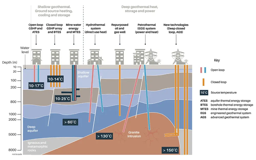
How to deposit data with the UK Geothermal Platform
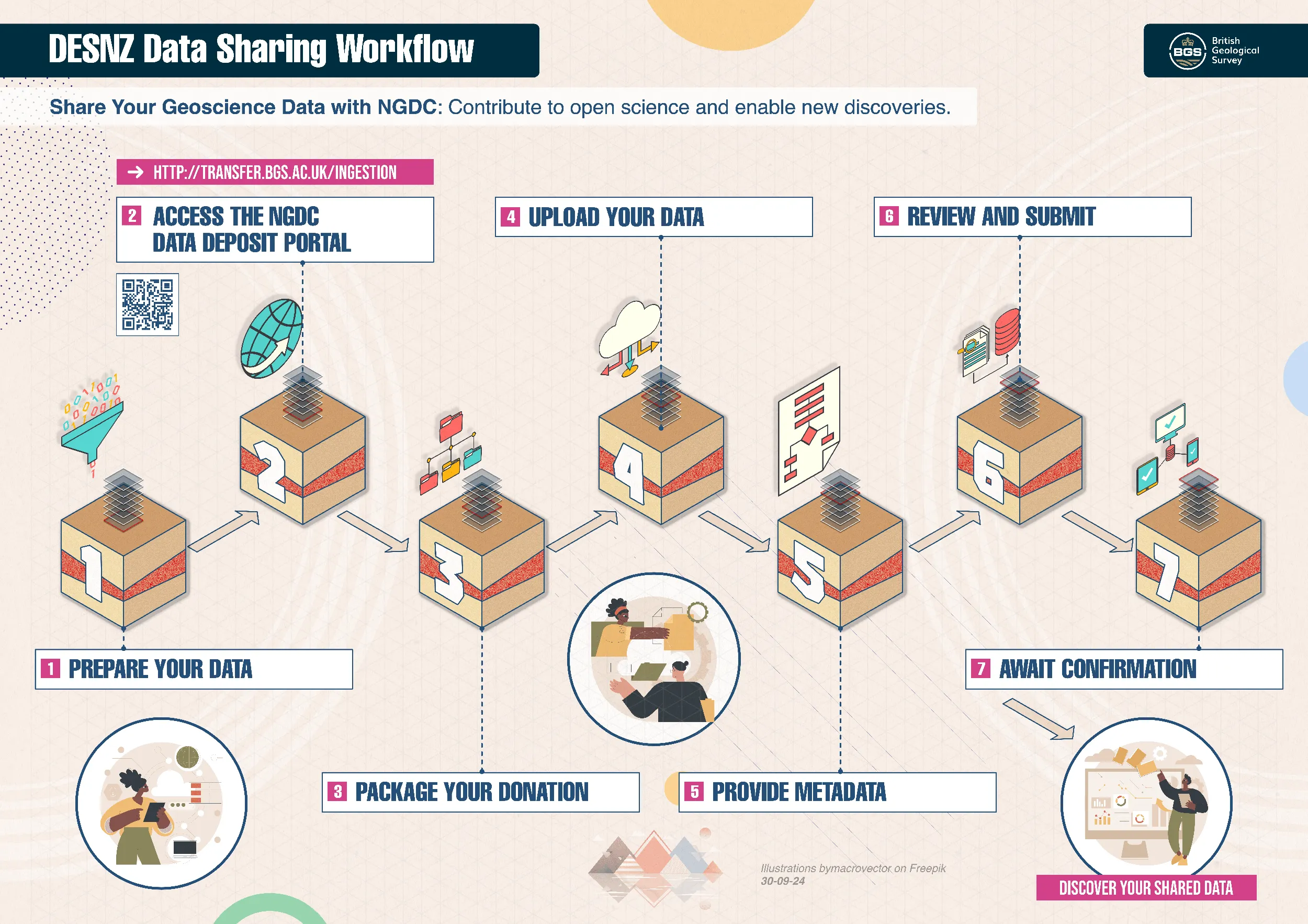
Geothermal data and information can be deposited into the BGS-hosted National Geoscience Data Centre (NGDC). From there, it may be incorporated into geothermal datasets or directly into future updates of the UK Geothermal Platform. NGDC provides secure storage according to international standards. Looking ahead, the aim will be to update legacy information and include new datasets.
Access the Deposit dataFrequently asked questions
How do I find out what I can do with the data and what the conditions of using it are?
The Geonetwork data search and download page includes all data in the UK Geothermal Platform, as well as license types and conditions of use. Please refer to each dataset you are interested in, as different conditions may apply to each dataset.
What are the licence terms on the data in the map explorer?
Some of the data is available under the Open Government Licence (OGL) to download, subject to the following acknowledgement accompanying the reproduced BGS materials: 'Contains British Geological Survey materials © UKRI [year]'
Some layers are available as a view-only service under the Open Government Licence.
Why can't I download all the data I can see in the UK Geothermal Platform?
For some layers, the information on the platform takes you to other organisations' websites where the data can be downloaded.
Some data is not available for download or cannot be supplied under licence. Reasons that some data is not available for download include legacy data with known limitations and due for upgrade, data with some sensitivity, or datasets that are part of an organisation's licensed products and services.
For BGS data, some of the view-only layers may be available to licence if users require access to the underlying data. The licence cost will generally be a licence administration fee (currently £165+VAT) depending on the usage type and the area coverage of the dataset requested. Companies and other commercial organisations with an interest in reselling BGS data or developing value-added products and services based on BGS data will need a BGS Data Resellers Licence.
How do I get in touch with BGS and staff involved in the development of UK Geothermal Platform?
Please contact our enquiries team (enquiries@bgs.ac.uk) and use 'UK Geothermal Platform' in the subject line.
Can you provide an overview of the data contained within the UK Geothermal Platform?

Detailed overview
The summary layers are new in version 1 of the UK Geothermal Platform. They are calculated from a range of national- and regional-scale legacy datasets. These legacy datasets, such as geothermal theoretical potential heat-in-place maps, heat flow and temperature maps, are available to access in the map explorer.
This is the first step in bringing together and making accessible national geothermal datasets. Future versions will incorporate updated information and data sourced from a greater number of organisations.
Key to overview of geothermal platform content
Normal text: view only under Open Government Licence (OGL); some layers are available to licence
Bold text: downloadable under OGL
Italics: transfer to external website to access detailed data
Abbreviations
- BGS: British Geological Survey
- DESNZ: Department for Energy Security & Net Zero
- EA: Environment Agency
- GSNI: Geological Survey of Northern Ireland
- MRA: Mining Remediation Authority
- NRW: National Resources Wales
- NSTA: North Sea Transition Authority
- OGL: Open Government Licence
- SEPA: Scottish Environment Protection Agency
- UKOGL: UK Onshore Geophysical Library
Geothermal summary potential
- DESNZ 2025 summary layers
- Overall and cost summary
- Closed-loop ground-source heat pump summary
- Open-loop ground-source heat pump summary
- Deep geothermal, hot sedimentary aquifer summary unit 1 (Triassic)
- Deep geothermal, hot sedimentary aquifer summary unit 2 (Permian)
- Deep geothermal, hot sedimentary aquifer summary unit 3 (Carboniferous/Devonian)
- Deep geothermal granites/EGS summary
- Mining Remediation Authority
- English cities mine-water heat opportunity mapping
- Wales mine-water heat opportunity mapping
Geothermal regional maps
- BGS (Rollin et al., 1995), Unit 1 Triassic Cheshire, Worcester, Wessex and East Yorkshire/Lincolnshire
- Faults top and faults base
- Depth to top
- Depth to base
- Base temperature
- Theoretical potential
- heat-in-place
- identified resources
- heat recoverable
- BGS (Rollin et al., 1995), Unit 2 Permian Cheshire and Worcester basins (Collyhurst Sandstone and Bridgnorth Sandstone)
- Faults
- Depth to base
- Base temperature
- Theoretical potential
- heat-in-place
- identified resources
- heat recoverable
- BGS, compiled 2011, Carboniferous Sandstone, Northumberland (Fell Sandstone)
- Faults (vertical and non vertical)
- Depth to base
- Temperature
- Theoretical potential
- heat-in-place
- identified resources
- heat recoverable
- BGS (Jones et al., 2023) Unit 3 Early Carboniferous Limestone
- Faults
- Depth to top
- Top temperature
- Theoretical potential
- heat-in-place
- heat recoverable
- BGS (Kearsey et al., 2024). Unit 3 Upper Devonian sandstone
- Faults
- Depth to base
- Top temperature
- Theoretical potential
- heat-in-place
- heat recoverable
Geothermal information
- BGS legacy geothermal catalogue
- BGS estimated temperature map of the UK (100 m depth) (Busby et al., 2009)
- BGS modelled temperature map of the UK (5 km depth) (Busby and Terrington, 2017)
- BGS modelled temperature map of the UK (7 km depth) (Busby and Terrington, 2017)
- BGS 2025 UK heat flow
- BGS 2025 thermal conductivity properties
- BGS and MRA 2021 British coalfields temperature maps
- BGS 2024 Deep geothermal areas
Boreholes and wells
- BGS boreholes
- NSTA Onshore hydrocarbon wells
- UKOGL UK Onshore Geophysical Library wells
- GSNI Northern Ireland boreholes
Seismic data
- UK Onshore Geophysical Library (UKOGL)
- BGS 2D seismic
- MRA 2D seismic
- MRA 3D seismic
- UKOGL 2D seismic
- UKOGL 3D seismic
Coal mining
- Mining Remediation Authority (MRA)
- Coalfield reporting area
- Borehole shaft temperature profiles
- Underground coal mine working extent
- Mine water treatment schemes
- Waste heat from treatment
- Heating demand
Geology
- BGS Great Britain superficial geology 50K
- BGS Great Britain superficial geology 625K
- BGS Great Britain linear features 50K
- BGS Great Britain faults 625K
- BGS Great Britain bedrock geology 625K
- GSNI Northern Ireland geology 250K
Hydrogeology
- BGS water wells
- BGS hydrogeology 625K
- EA
- England groundwater bodies
- England monitoring stations
- England source protection zones
- NRW
- Wales groundwater bodies
- Wales source protection zones
- SEPA
- Scotland groundwater classification and quality
Other geoscience maps
- BGS engineering geology classification (bedrock)
- BGS engineering geology classification (superficial)
- BGS thickness of superficial deposits (hex grid)
Environmental protection and regulation
- National parks
- England
- Wales
- Cairngorms National Park
- Loch Lomond and The Trossachs National Park
- Great Britain sites of special scientific interest
- NSTA
- Hydrocarbon fields
- Methane vents
- Oil and gas licence blocks
Data access
- Metadata records, links to downloads
- Links to frequently requested and legacy reports
- Links to selected standards and drilling guidance
- Existing summary and screening tools
- Links to time series data streams from BGS, EA, SEPA, NRW, MRA
Why are there multiple sources of borehole and well data?
Different data and information are accessible from different organisations. There is also overlap between datasets. Find more information in Table 1.
| Layer | Description |
|---|---|
| BGS Boreholes |
The BGS Single Onshore Borehole Index (SOBI) includes links to view scans of the original borehole record. There are over 1 million onshore drilling and site investigation records, from very shallow to thousands of metres in depth. |
| NSTA (North Sea Transition Authority) onshore hydrocarbon wells | Onshore hydrocarbon (oil; gas; coalbed methane; shale gas) wells, including producing wells. Index level information is provided in the UK Geothermal Platform, along with a link to the North Sea Transition Authority (NSTA) viewer where there is more detailed information. |
| UKOGL (UK Onshore Geophysical Library) wells |
A collection of deep hydrocarbon wells, coal boreholes (sometimes called Coal Board or NCB boreholes) and stratigraphical boreholes distributed by the UK Onshore Geophysical Library (UKOGL). Index level information is provided in the UK Geothermal Platform, along with a link to the UKOGL viewer where scans of associated records, LAS files, well tops, etc., can be viewed and downloaded. The data is a mixture of wells drilled under licence (from NSTA), wells donated to UKOGL, data digitised by UKOGL or data supplied by BGS. There are overlaps with NSTA and BGS data holdings. However, some data is held by UKOGL only and there is access to well-top information. |
| GSNI Northern Ireland boreholes | Records of onshore boreholes, shafts and wells held by the Geological Survey of Northern Ireland (GSNI). |
| BGS geophysical well records (not in version 1) |
Available in BGS Geoindex BGS holds geophysical logs in paper or digital form, of varying quality and vintage. There are some overlaps with UKOGL data holdings (who more commonly have LAS files) and some data is held by BGS only. |
| Hydrocarbon wells linked to BGS-held data (not in version 1) |
Available in BGS Geoindex The onshore hydrocarbon wells have links to scans of data held by BGS. There are overlaps with UKOGL data holdings. Some data is held by BGS only. |
| BGS-held 'core sample analysis-OGA wells' linked to data (not in version 1) |
Available in BGS Geoindex Links to core sample analysis data produced from sampling activities of core held on behalf of the NSTA (formerly OGA) at the National Geological Repository, Keyworth. |
Why are there several seismic data layers?
Reflection seismic data originates from several organisations, all served via the UK Onshore Geophysical Library (UKOGL). The locations are included in the UK Geothermal Platform; images generated from seismic data and more information are available via the UKOGL interactive map viewer.
The seismic data layers are:
- UKOGL 2D and 3D seismic surveys collected either by companies during hydrocarbon exploration under licence from the North Sea Transition Authority (NSTA) or its predecessors, or by voluntary donations made to UKOGL from legacy collections
- 2D seismic surveys collected on behalf of BGS or its predecessors (for example, IGS)
- 2D and 3D seismic surveys collected on behalf of the Mining Remediation Authority or its predecessors (Coal Authority; National Coal Board).
What do the different geothermal output terms mean?
The map explorer contains a number of terms for geothermal heat estimations, particularly for deep geothermal, hot sedimentary aquifers. The terms span the total heat-in-place in the subsurface, as well as estimates of theoretical potential recoverable heat energy after applying standard factors (Figure 2).
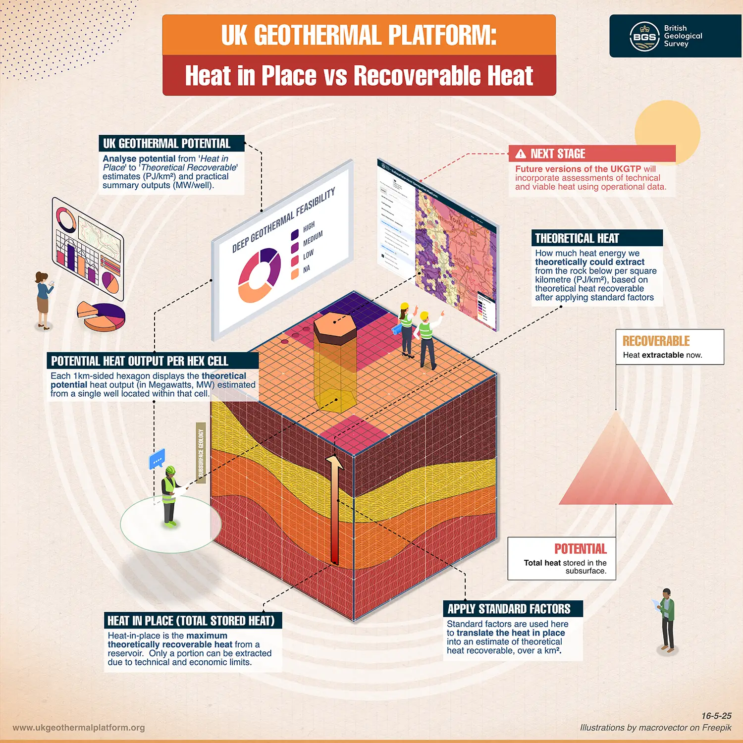
The legacy studies incorporated into the UK Geothermal Platform took two different approaches to estimating geothermal heat capacity, further complicating the terminology (Table 3). A conversion has been made to provide roughly equivalent values of theoretical potential recoverable heat from previously published, estimated 'geothermal resources' and 'identified resources' (see 'Calculations' in Summary Layer Methodology report). The terminology used in the legacy studies is not consistent with the UNFC classification scheme (pdf).
| Name used in UK Geothermal Platform | Depth (mAOD) | Temperature (°C) | Theoretical heat-in-place | Theoretical potential recoverable heat | Heat extractable from 1 doublet |
|---|---|---|---|---|---|
| Unit 1 Triassic sandstone (Cheshire, Worcester, Wessex, East Yorkshire and Lincolnshire basins) (Rollin et al., 1995; BGS method) |
Top SSG (all) Base SSG (Cheshire and Worcester only) |
Base SSG | Referred to as 'Geothermal Resource' in Rollin et al., (1995) (PJ/km2) (original maps in GJ/m2; 1 GJ/m2 =1 PJ/km2) |
Referred to as 'Identified Resource' in Rollin et al. 1995 (PJ/km2) Factor applied to make consistent with the more recent studies (for example, to same recovery factor, plant lifetime, etc.). Updated values are called 'HREC' or theoretical potential recoverable heat in MW/km2 |
Summary layer — total heat extractable from 1 doublet (MW), assuming 1 well placed in a hex cell, calculated using the theoretical potential recoverable heat |
| Unit 2 Permian sandstone (Cheshire and Worcester basins) (Rollin et al., 1995; BGS method) | Base Permian | Base Permian | |||
| Unit 3 Carboniferous sandstone (Northumberland - Solway basin) (BGS method as in Rollin et al. 1995 | Base middle Border Group (Fell Sandstone) | Base Permian | |||
| Unit 3 Carboniferous limestone (Jones et al., 2023; 3D HIP method) | Top early Carboniferous limestone | Top early Carboniferous limestone | Mid middle Border Group (Fell Sandstone) | Theoretical potential recoverable heat (MW/km2) | |
| Unit 3 Upper Devonian sandstone (Midland Valley, Scotland) (Kearsey et al., 2024; 3D HIP method) | Top Upper Devonian | Base Upper Devonian |
References
Busby, J, and Terrington, R. 2017. Assessment of the resource base for engineered geothermal systems in Great Britain. Geothermal Energy, Vol. 5, 7. DOI: https://doi.org/10.1186/s40517-017-0066-z
Busby, J, Lewis, M, Reeves, H, and Lawley, R. 2009. Initial geological considerations before installing ground source heat pump systems. Quarterly Journal of Engineering Geology and Hydrogeology, Vol. 42(3), 295-306. DOI: https://doi.org/10.1144/1470-9236/08-092
Jones, D J R, Randles, T, Kearsey, T, Pharaoh, T, and Newell, A. 2023. Deep geothermal resource assessment of early Carboniferous limestones for central and southern Great Britain. Geothermics, Vol. 109, 102649. DOI: https://doi.org/10.1016/j.geothermics.2023.102649
Kearsey, T I, Receveur, M, and Monaghan, A A. 2024. Modelled hot sedimentary aquifer geothermal potential of Upper Devonian strata in the Midland Valley of Scotland. British Geological Survey Open Report OR/24/030. Nottingham, UK: (British Geological Survey). (Unpublished.) Available from https://nora.nerc.ac.uk/id/eprint/538341/
Rollin, K, Kirby, G A, Rowley, W J, and Buckley, D K. 1995. United Kingdom. 61-64 in Atlas of Geothermal Resources in Europe. Hurter, S, and Haenel, R (editors). (Publications Office of the European Union, 2002.) Available from https://op.europa.eu/en/publication-detail/-/publication/9003d463-03ed-4b0e-87e8-61325a2d4456. ISBN: 92-828-0999-4. Also available as British Geological Survey Technical Report WK/95/07.
What types of hydrogeology (groundwater) data have been included?
Groundwater body classification, groundwater quality and source-protection zone layers have been included (where available) from environmental agencies for England, Wales and Scotland. The locations of groundwater monitoring and sampling points have been included where open data is available from data streams, in addition to the BGS 625K hydrogeology map. Table 5 provides an overview of hydrogeology data that is included in the UK Geothermal Platform and, where more information is available, from the environmental agencies.
| Layer | Description | More information |
|---|---|---|
| BGS observed water levels (not in version 1) | Available in BGS Geoindex. Sites where regularly monitored rest water-level data is available. This is an index, rather than facilitating direct access to data. | Not applicable |
| BGS water wells | Subset of the borehole records (SOBI) dataset showing water wells as held in the Wellmaster hydrogeological database. Present-day public abstraction boreholes are not displayed. | Not applicable |
| BGS aquifer properties data (not in version 1) | Available in BGS Geoindex. This layer is an index, rather than facilitating direct access to data. | Not applicable |
| BGS hydrogeology 625K | 1:625 000-scale hydrogeological data for use as a guide to the aquifers at a regional or national level. | Not applicable |
| EA England groundwater bodies | Groundwater bodies in England from the Water Framework Directive Cycle 2 (from the Environment Agency). | Not applicable |
| NRW Wales groundwater bodies | Groundwater bodies in Wales from the Water Framework Directive Cycle 3 (from Natural Resources Wales). | Not applicable |
| SEPA Scotland groundwater classification and quality | The status of groundwater in Scotland, classified under the Water Framework Directive scheme and links to information on groundwater quality (from the Scottish Environmental Protection Agency). | Water quality data |
| EA England groundwater level stations | All types of monitoring stations are included | Hydrology explorer |
| NRW Wales groundwater level stations (not in version 1) | Not applicable | Apply to NRW |
| SEPA Scotland groundwater level stations | Not applicable | Not applicable |
| EA Groundwater water-quality data (not in version 1) | Not applicable | Water quality archive |
| EA England Source Protection Zones | EA source protection zones (merged) | Not applicable |
| NRW Wales groundwater quality data (not in version 1) | Not applicable | Apply to NRW |
| NRW Wales source protection zones | NRW source protection zones (merged) | Not applicable |
How do I get more information from non-BGS data layers?
The UK Geothermal Platform is a hub, incorporating information from a range of organisations. Index level information from the Mining Remediation Authority, UK Onshore Geophysical Library, North Sea Transition Authority and environmental agencies is incorporated.
To access the full functionality from those organisations, users can click on the link at the bottom of the pop-up information. This will open the organisation’s web page or data access pages in a new tab.
An example is the groundwater classification and quality layer for Scotland. Basic information is provided in the pop-up in the map explorer; the link takes the user to the SEPA website, where detailed groundwater chemistry data can be found.
What if I think a data layer is missing?
Datasets were prioritised for inclusion in this first version of the UK Geothermal Platform. The criteria included:
- feedback from a stakeholder workshop
- national coverage
- open access
- available as a WMS
Reasons that data is not currently included are:
- it does not exist in unified form (for example, geothermal asset register; artesian water; porosity/permeability model; heat network locations)
- it does not exist as open access or in suitable digital form (for example, it may exist but have the wrong map projection to be included)
- it is out of the scope of this version (for example, underground thermal energy storage technologies; other heat sources; drilling hazards)
We hope to incorporate a greater range of datasets in the future. Please contact us (enquiries@bgs.ac.uk) if you have suggestions.